Underground Connectivity & RTLS: Fleet and Personnel
Learn how underground connectivity and RTLS support reliable fleet tracking, personnel visibility, safety and faster operational decisions.
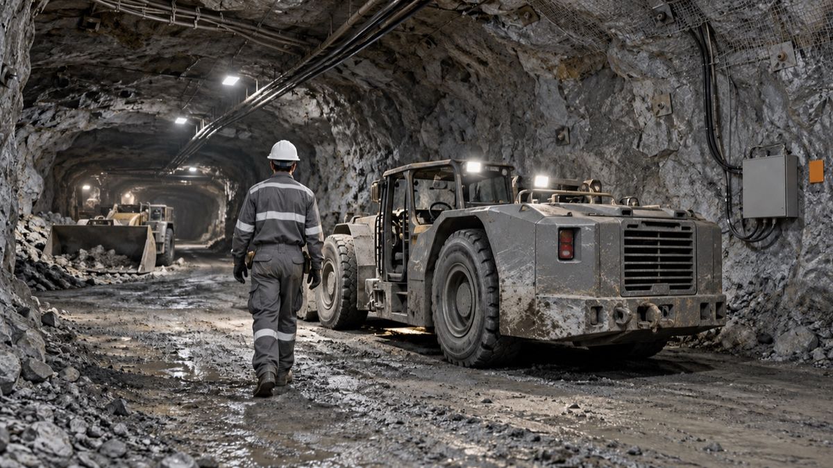
Underground Connectivity and RTLS for Fleet and Personnel Tracking
Reliable underground tracking starts with the network. RTLS cannot provide real-time visibility when coverage disappears between working areas.
An underground loader leaves a drawpoint, but its location on the control-room map does not update.
Two technicians are working nearby. Their personnel tags last reported several minutes ago. The supervisor cannot confirm whether the loader is delayed, outside coverage or approaching the same work zone.
The mine has a tracking system, but it does not have reliable operational visibility.
This is the central challenge with underground connectivity and RTLS. Tags, maps and dashboards only work when the communications network can carry accurate location data across changing tunnels, ramps and production areas.
Key Takeaway
Underground connectivity provides the communication layer, while a real-time location system identifies where personnel, vehicles and equipment are located. Mines should design both together, starting with the operational use case, required location accuracy and coverage needed across active areas, travel routes and emergency zones.
What Are Underground Connectivity and RTLS?
Underground connectivity is the communications infrastructure that allows people, equipment, sensors and operational systems to exchange information below the surface.
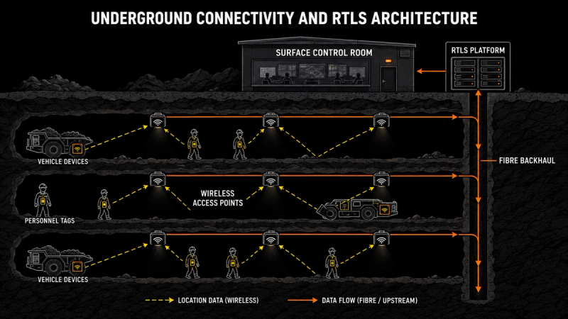
It may include fibre backhaul, leaky feeder, Wi-Fi, private LTE or 5G and supporting edge infrastructure.
A real-time location system, or RTLS, uses tags, devices and network signals to estimate or confirm the location of people and assets. Depending on the technology, it may show that a worker entered a zone or provide a more precise position within that zone.
Together, connectivity and RTLS support:
- Underground personnel tracking
- Fleet and asset visibility
- Voice and emergency communication
- Collision-risk awareness
- Remote or autonomous equipment
- Environmental monitoring
Without connectivity, the tracking platform receives incomplete or delayed information. Without RTLS, the network may carry data but still cannot show where people and equipment are operating.
Why Underground Tracking Is Difficult
Satellite-based positioning does not provide normal surface-level coverage through rock. Underground mines must create their own communications and location infrastructure.
The environment also changes continuously. New headings are developed, old areas close and mobile equipment moves between levels and production zones.
Curves, intersections, rock conditions and underground infrastructure can affect signal performance. A network designed around last year’s mine plan may no longer cover the areas controlling today’s production.
This is why real-time visibility in underground mining depends on continuous network planning rather than a one-time installation.
The Four Layers of an Underground Tracking System
A reliable tracking system requires four connected layers:
Layer | Role | Common failure |
|---|---|---|
Backhaul | Carries data between underground areas and surface systems | Limited redundancy or damaged infrastructure |
Access network | Connects vehicles, tags, phones and sensors | Coverage gaps and weak handovers |
Tags and devices | Generate identity, status and location signals | Dead batteries or incompatible hardware |
RTLS software | Displays locations, zones, alerts and movement history | Delayed data or poor integration |
A failure in any layer can create false confidence in the location information shown to the control room.
The mine should therefore monitor network health and tracking performance separately. A dashboard that is online does not prove that every underground area is reporting correctly.
Choosing the Right Underground Connectivity Technology
There is no single network technology that suits every mine.
The right choice depends on tunnel layout, mobility, bandwidth, existing infrastructure, equipment compatibility and how often the mine changes.
Technology | Typical strength | Practical consideration |
|---|---|---|
Leaky feeder | Established underground voice communication | Data capacity and tracking functions depend on system design |
Wi-Fi | High data capacity within covered areas | Requires careful access-point placement and handover planning |
Private LTE or 5G | Broad mobility, voice, data and automation support | Requires spectrum, infrastructure and compatible devices |
RFID or BLE | Cost-effective identification and zone-level tracking | May not provide precise continuous positioning |
UWB | High location accuracy in defined areas | Best used selectively where precision justifies the infrastructure |
Many mines use a combination. Leaky feeder may continue supporting radio communication while Wi-Fi or private cellular carries operational data. RFID or Bluetooth tags may track movement between zones, while higher-accuracy technology covers workshops or interaction points.
The decision should begin with the required outcome, not the newest network option.
Define the Tracking Requirement Before Buying Technology
“Real-time tracking” can mean different things.
A control room monitoring fleet flow may only need to know when a loader enters or leaves a production zone. A collision-avoidance use case may require faster updates and much greater accuracy.
Before selecting technology, define:
Who or what must be tracked? Personnel, light vehicles, LHDs, trucks, service equipment or high-value tools may require different devices.
Where must tracking work? Prioritise active headings, declines, workshops, refuge chambers, loading areas and travel routes.
How accurate must the location be? Zone-level location may support workforce visibility, while high-risk interactions may require more precise positioning.
How quickly must the data update? Emergency response and vehicle interaction need faster information than equipment inventory.
This prevents the mine from paying for high precision everywhere when only selected areas require it.
Use RTLS for Fleet Tracking, Not Just Map Visibility
Underground fleet tracking should help the mine understand movement, availability and production flow.
Knowing that an LHD is located in a heading is useful. Knowing that it has remained there longer than expected while a truck waits at the transfer point is operationally valuable.
RTLS data can help identify:
- Equipment waiting in inactive areas
- Loader and truck mismatches
- Congestion at intersections or loading points
- Long travel and response times
- Service vehicles delaying production traffic
The location feed should connect with task status, dispatch information and production targets. Otherwise, the system shows movement without explaining its effect on the shift.
This information can feed an integrated mining command and control centre, where fleet, maintenance and production teams can coordinate their response.
Improve Personnel Visibility and Emergency Response
Personnel tracking helps a mine confirm who is underground, where they were last detected and whether they entered a restricted or hazardous zone.
In the United States, the MINER Act requires relevant underground coal operations to include communication and electronic tracking capabilities in emergency response planning. MSHA’s communication and tracking guidance also notes that equipment used in gassy underground mines may require appropriate approval.
Requirements vary across jurisdictions and mine types. The operational need is broader than compliance.
During an emergency, the mine needs location information that is current, understandable and available when normal infrastructure has been disrupted. This makes backup power, network redundancy and last-known-location records essential design considerations.
Personnel location can also support autonomous workforce management in mining by connecting worker location with assigned tasks, competencies and restricted-zone permissions.
What Private LTE Can Enable Underground
Private LTE and 5G are increasingly used where mines need mobile voice, operational data and automation across large underground areas.
At Nutrien’s Rocanville potash mine, a private LTE network was introduced to improve voice and data communication across extensive underground travel ways. According to the Ericsson and Nutrien case study, the network helped move critical information from underground operations to the control room more quickly.
Agnico Eagle also deployed private LTE at its LaRonde Complex, extending connectivity approximately 3.2 kilometres underground. The Agnico Eagle case study describes support for continuous asset-location monitoring, remote operation and environmental data.
These examples show what private cellular can support. They do not mean every mine needs 5G. A smaller operation with limited automation requirements may achieve its objectives with a well-designed Wi-Fi, leaky-feeder or hybrid network.
A Practical Personnel-Tracking Example
Consider an underground operation with three active production levels.
A ventilation alarm requires personnel to leave one level and report to designated safe areas. The control room receives check-ins from most workers, but one contractor remains unconfirmed.
The RTLS shows the contractor’s last recorded location near an underground workshop. Instead of searching the entire level, the response team can focus communication and verification on that area and the likely exit routes.
The worker is contacted and confirmed safe. The event record later shows that the person had entered a section with inconsistent network coverage, which delayed the location update.
The mine can now correct the coverage gap before another event occurs.
RTLS does not replace formal emergency procedures or physical accountability checks. It gives the response team faster location context when time and certainty matter.
Build for Network Failure and Mine Expansion
Underground connectivity should be designed around failure, not only normal operation.
Critical infrastructure needs backup power, protected routes and clear recovery procedures. The control room should be able to distinguish between a person who stopped moving and a tag that stopped reporting.
The network must also expand with the mine. Coverage planning should be included in development schedules so new working areas do not begin production before communications and tracking are ready.
Track practical network measures such as coverage by active area, device connection rate, location-update delay, tag battery status and time required to repair failed infrastructure.
How to Implement Underground Connectivity and RTLS
A phased rollout reduces risk and makes the business case easier to verify.
- Select the operational use case. Begin with personnel safety, fleet flow, emergency communication or another defined problem.
- Survey the active mine. Map current coverage, blind spots, infrastructure routes and future development.
- Set accuracy and update requirements. Avoid specifying high precision where zone-level tracking is sufficient.
- Pilot one operating area. Test normal movement, shift changes, network failure and emergency conditions.
- Connect location data to action. Define who responds to lost tags, restricted-zone entry, congestion and abnormal dwell time.
The pilot should be measured by operational outcomes, not only network uptime.
How AIM Turns Location Data Into Operational Action
AIM Vision is the situational-awareness module within the wider AIM platform from HonestDig.
It brings workers, vehicles, tasks and operating zones into one real-time view. Location information is connected with task status and site conditions so teams can understand what is happening without switching between separate tracking and operational systems.
Alerts can be placed in context, helping supervisors distinguish between routine movement, developing congestion and events requiring intervention.
This supports a predictive site-resilience model in which location data becomes part of coordinated operational response.
Schedule a demo to see how AIM connects underground location data with site-wide decisions.
Frequently Asked Questions
What is RTLS in underground mining?
RTLS is a real-time location system that uses tags, devices and underground network infrastructure to identify the location of personnel, vehicles and equipment.
Why does GPS not work reliably underground?
Satellite signals do not provide normal coverage through rock. Underground mines must use local communication and positioning infrastructure such as Wi-Fi, private cellular, RFID, BLE or UWB.
What is the best network for underground mining?
There is no universal answer. The right network depends on mine layout, required coverage, mobility, bandwidth, equipment compatibility and the intended tracking or automation use case.
What is the difference between RFID and UWB tracking?
RFID is commonly used for identification and zone-level detection. UWB can provide more precise positioning within defined areas but usually requires additional infrastructure.
Can RTLS track both mine personnel and vehicles?
Yes. Different tags and devices may be used, but personnel and fleet locations can be presented through one operational platform.
How does underground RTLS improve safety?
It helps mines confirm who is underground, identify restricted-zone entry, support emergency response and understand the proximity of people and equipment.
Should an RTLS project begin with network installation?
It should begin with the operational use case and required location performance. The network should then be designed to support those requirements across the relevant underground areas.